Google+

Tirathgarh Waterfalls

Known as Milky Fall.

Chitrakot Waterfall

Known as Mini-Niagara Falls

Bastar Dussehra

They dont burn Ravan, its a different story

Famous Mama Bhanja Temple and Lord Ganesha Idol

Barsur have many more surprises

Chhattisgarh Tribal

Unchanged way of living and let me introduce you to a village!!

About

Siddheshwar Temple, Palari, Balodabazar


Siddheshwar Temple, Palari, Balodabazar
 (A blog by Jitendra Nakka)


Introduction


The district of Balodabazaar lies in the central part of the Chhattisgarh state and blessed with some of the most beautiful ancient temples of Chhattisgarh, depicting the glorious history of area. One such perfect religious place in Balodabazaar is Palari’s ancient shiv temple also called Siddheshwar Temple.
                    Figure:Front Side View of Siddheshwar temple, Palari 


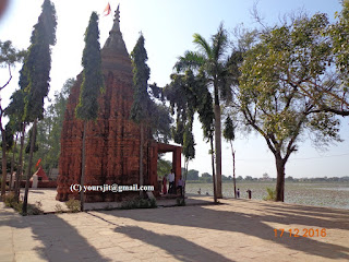
                   Figure:Back Side View of Siddheshwar temple, Palari 


Where and How to reach?

Palari town is the block Head Quarter of Palari of Balodabazaar District and situated nearly 65 km North of State Head-Quarter, Raipur and nearly 15 kms South of district Head-Quarter, Baloda-Bazaar. Here, the ancient Shiv temple lies 2 kms East of Palari near the outer of township at the bank of Bal-Samund Pond. This place is approachable throughout the year as it lies directly on the Raipur-Balodabazaar State Highway. The Nearest Railway Station and Airport is Raipur. Nearby Raipur and Balodabazaar, there are many luxurious hotels which interesting tour packages to tourists. 

                                        Figure: Siddheshwar temple


Salient Features:

            Siddheshwar temple lies on the bank of Balsamund pond, and built in a manner of old brick made construction, gives it a unique distinction, next to Laxman temple of Sirpur. The experts have observed ornamentation of different type of Goddess and Goddesses on the outer wall of temple like Kartik, Ganesh, Gaj-laxmi. On the contrary, the inner walls of the temple are rather ornamentation-less.
                Figure: Brick carved statue of Lord Ganesha on the outer Wall

                               Figure: Shivling in the Garbh-Griha

            The temple seems to have two chambers where the first chambers looks like an open mandap followed by Garbh-Griha which is the second and the main chamber. The front of the Garbh-Griha is ornamented by stone carved idols of Goddesses Ganga and Yamuna while the fore-head or the space above the Garbh-Griha is occupied by exotic carvation of Marriage Ceremony of Lord Shiva where  thrice of the dev (tridev) are said to have appeared with each other. Being one of the best examples of brick-made constructions of Central India, Palari Shiv Temple is believed to have been built during 7th -8th Century.  
Figure: Statue of Ganga and Jamuna in the either side of Entrance Gate of Garbh-Griha

            On the left side of courtyard/campus of the temple, where there is a Pipal tree, where a recent found idol of Siddh-Baba is placed openly, in order to exhibit the external excavations. There are few temples nearby which have been constructed recently.
                                       Figure: Siddh Baba Idol


Conclusion:

            This place is an ideal place for historians to read and obsercve the ancient brick-made buildings of Central India. I believe this temple has the potential to drive everybody’s attention, if proper promotion of this place is done.


Siddh-khol Waterfall, Kasdol, Baloda-bazaar

Siddh Khol Waterfall (Kasdol, Balodabazaar)
(A blog by Jitendra Nakka)


Introduction

Chhattisgarh plains homes some of the scenic landscapes of Central India. But inspite of this landform feature, there are some places which are well-versed with small undulated hills like the block of Kasdol of District Balodabazaar. Kasdol is the block which is gifted by natural beauty of small mounts, open forest and some of the most untrodden waterfalls. One among them is Siddh-khol Waterfall, popularly renowned as Siddh-Baba.
Pic: Siddh-khol Waterfall (with Author and Group)
Where and how to reach?
    Siddh-khol Waterfall is nearly 122 kms from State Head-Quarter Raipur at Kasdol-Pithora State Highway. For reaching Siddh-khol Waterfall, one has to reach Kasdol block of Baloda-bazaar district, from where this marvel is just 12kms away towards Pithora. After a smooth highway ride of about 11 kms, one has to follow a concrete road track of about 1km to reach this site.
Pic: Location Map of Siddh-khol Waterfall (near Kasdol, Baloda-bazaar)
(C) www.mapsofindia.com

    Siddh Baba is approachable throughout all the seasons of a year, but as the Waterfall receives its flow through a small brook actually formed from the collection of water from fields above, Rainy and Early Winters are the season advisable to visit this beautiful location. Raipur and Bhatapara are the nearest railway stations for this place. In addition, Raipur is the closest airport to this site. 
   
Salient Features
    Being at Siddh-Baba, makes you go completely spellbinding. Siddh-baba is actually a small valley where the water-flow from the brook above, plunges down nearly 40 feets down to form a mesmerizing waterfall known as Siddh-khol Waterfall. In addition to it, there is one legendary story attached to it. People believe that in past, there was one holy sage known as Siddh Baba, after whom this waterfall has received its name.
 Pic: Siddh-Baba temple  (with Author and Group)

 Pic: Siddh-khol Waterfall

Pic: Siddh-khol Waterfall (with Author and Group)

As we descend down to this valley, we have to complete nearly 50 stairs to reach up to the reservoir (Water-pool) down the fall. The reservoir is nearly 5 feet deep surrounded by thick vegetation far up to the extent of valley. The water from the brook falls from a great height of 40 feet and makes its way further to the valley, during rainy season, but as the brook starts drying and the flow of the brook becomes thin, the falling water is compelled to get collected in the reservoir itself.
Pic: Reservoir of Siddh-khol Waterfall

Pic: Reservoir of Siddh-khol Waterfall

The mesmerizing fall of Siddh-baba also adores a sandstone grotto like feature on its right side bank. For reaching this grotto, one has to take a circumference of reservoir of Siddh-Baba to reach its right bank side, where this grotto is located nearly 15-20 feets above the foot-hill of Waterfall.
Pic: Grotto near right side bank of Siddh-khol Waterfall (with Author and Group)

 
 Pic: Grotto near right side bank of Siddh-khol Waterfall (with Author)

Pic: Grotto near right side bank of Siddh-khol Waterfall

Conclusion:
Just a first view of this marvel leads to immense satisfaction. Watching the thick greenery and vegetation of this valley, will let you truly amazed. On the whole, this place is purely a must visit site.
Pic: Author and group

In addition to your adventurous trip, you can also visit ancient Shiv Temple of Narayanpur nearby which is believed to have built during the reign of Great Kalchuris.   

Siya-Devi Waterfall, Balod

 Siya-Devi Waterfall (Naragaon, Balod)
(A blog by Jitendra Nakka)

Introduction

Day: 10th September 2016, Time: 8.30 a.m., me and my dear friend Ashish Gadpale are heading for Balod. Balod is a district which is famous for its megalithic sites like Karkabhat, Dhanora, karhibhadar, kuliya, Bhujgahan etc.  Numerous archeological sites like Bahadur-kalarin ki Maachi, Madiyapaat, kukurdev temple etc. still strive to gain their first name in the field of tourism in Chhattisgarh. Every block of Balod has its own story, whether it may be archeological ancient temples, megalithic sites, natural waterfalls, or Huge reservoir and dams. Balod has everything to prove itself a worthy tourist site. The only thing it demands is the attention of tourists. One of the most beautiful tourist sites in Balod is Siya-devi Waterfall

 Picture: Siya-Devi Waterfall
 
Where and how to reach?
 Siya-devi Waterfall is nearly 16kms away from Balod towards Balod-Charama State Highway. From Balod, one has to reach Jhalmala, a small town near district Headquarter,Balod. From Jhalmala, one has to travel 12 kms towards Balod-Charama SH, lastly followed by a 2-3km journey of kachcha road(towards left side) to reach our final destination called as Siya-devi Waterfall.
  Picture: Location Map (C) www.mapsofindia.com

    Siya-devi WF is approachable throughout all the seasons of a year, but as the Waterfall receives its flow from a brook above, Rainy and Early Winters are the season advisable to visit this beautiful location. Raipur is the nearest railway stations for this place. In addition, Raipur is the closest airport to this site. 
   
Salient Features
    The Jaw-dropping beauty of Siya-devi has the ability to drive attention of anybody who loves nature. Siya Devi is a holy place named after Goddess Sita. There are some mythological and legendary stories also attached with this place.

•    Mythological Importance:

This place comes under Dandakaranya region of ancient times. It is believed that Lord Ram was tested by Goddess Parvati in the form of Goddess Sita, to test his loyalty towards His wife, Sita(at the time when he was in search of his wife, who was forcibly kidnapped by Demon king, Ravana). Lord Ram recognizes Goddess Parvati and greets her as his mother and asks the reason for coming in the middle of Jungle all alone. Satisfied by the loyalty of Lord Ram, Goddess Parvati feels shame for her deed and discusses all the matter with Lord Shiva and apologizes. Lord Shiva advises her to settle down at Siya-devi as the incarnation of Goddess Sita. This is how this place came to known as Siya-devi.
There is one more belief that the tiger of Goddess here awakes (comes into life) in night times and protects the holy region. Hence, the statue of tiger here is fastened here by a thick iron chain. 
 
The waterfall here is about 15-20 feet high and 35-40 feet wide. A brook near this area plunges down to a height of about 15-20 feet to make this beautiful waterfall. As the passage of water falling and flowing down the stream near down-stream is full of boulders, it becomes easy for tourist to come quite near to fall and enjoy the beauty of it.
 Pic: Siya-Devi Waterfall (Side view)

 Pic: Author with his friend Mr. Ashish Gadpale 

Pic: Mr. Ashish Gadpale with Waterfall

Another wonder of this place is the cave nearby left side bank of upstream, which is actually a joint fracture between rocks which leaves a thin space to enter inside and has a end outside. Other than Turturiya village of Bar-Navapara Sanctuary, this place is also famous for Meditation Land of Maharishi Valmiki and also known as Valmiki Gufa.
Pic:Entrance of Cave (with Author)

Pic: Idol of Maharishi Valmiki near Grotto of Cave outside

Pic:End of Cave
Conclusion:
This site is a perfect combination of pilgrimage with tourism. This site has some of the most important temples of the district. People have great dignity for Siya-devi temple as the holy pilgrimage. And this place is covered by great density of devotees during Navratri and Maha-shivratri. As perfect eco-tourism place, this site has great potential to be good tourist spot.
 Picture: Siya-Devi Waterfall (stream passage)
In addition to this, a tourist can also visit Tandula Dam, Ganga Maiya Temple(Jhalmala) and Rani Mata temple(Narra-village) as the nearest temples. Last but not the least, I want to give thanks to Mr. Tulesh Sahu for guiding us to this marvel.

Jatmai-Ghatarani Waterfalls, Gariaband


 Jatmai-Ghatarani Waterfalls (Gariyaband)
(A blog by Jitendra Nakka)


Introduction


Depicting the beauty of the Central Plains of Chhattisgarh, Gariyaband is one of the most beautiful districts of state.  Gariyaband is the home of some of the most beautiful waterfalls. Among them, the most beautiful waterfalls are the falls of Jatmai and Ghatarani
 Image: Ghatarani Waterfall


Where and how to reach?

            Jatmai-Ghatarani Waterfalls are actually two different waterfalls 6kms away from each other. Jatmai-Ghatarani is nearly 90 kms from State Capital Raipur and nearly 40 kms from District Head Quarter. Just 20 kms away from Gariyaband, there is a village called Panduka, towards Gariyaband-Rajim State Highway, from where Jatmai Waterfall is nearly is 20-22 kms away. For reaching Ghatarani,  again we have to start our journey from Jatmai and take the straight forest road which after a couple of miles, turns into a kachcha road, which after next 4kms leads to our next beautiful destination called Ghatarani. 

Site Map of Jatmai Ghatarani Waterfalls
(Courtsey: www.mapsofindia.com)

            Both the Waterfalls are approachable throughout the year, as it is just 20-22 kms east from State highway. Here the months of rainy and early winter season are most advisable for visiting these wonders. As Panduka village is directly on the State Highway, one can find good hotels, lodges and restaurants in Raipur, Gariyaband and Rajim and can plan their tour-plan from there.
  
Salient Features


  • Experience being at Jatmai Waterfall:         

This area actually comes under Chhura block of Gariyaband District. Welcoming with the roaring sound of Falls, Jatmai is divine spiritual place famous for its milky waterfall as well as Goddess Durga temple centrally placed in a rocky sanctum in a sharp thin grotto down to middle of the left side of bank of fall. The fall is 20 feet high (approx.) flowing with a milky cascade of Water from upstream. 
 Image: Mata Jatmai Temple

 
 Image: Jatmai waterfall with temple

  Image: Jatmai waterfall with temple

Both the banks of Jatmai fall are witness of some of the most beautiful temples of district, painted in white colour everywhere, complimenting the milky colour of falls. The upstream can be traversed quite up to a long distance. Tourists love to do hiking and climbing sort of sports. Other than the fame of religious waterfall, this place is also famous for water-sports.

  • Experience being at Ghata-rani Waterfall:

Ghatarani waterfall is a bit larger than Jatmai waterfall and nearly 6kms from Jatmai Waterfall from a kachcha road directly leading to Ghata-rani Waterfall.  Ghatarani is nearly 30-35 feet wide and 25-30 feet in height with a divine sanctum of Goddess Durga on the right bank of fall, which is known as Mata Ghatarani temple. This place too holds the same importance as Jatmai Waterfall. 
 Image: Mata Ghatarani Temple

The upper most side of waterfall is formed as cascade upto first 5 feet, followed by formation of cataract up to 20-25 feet reaching the foot of the falls. The foot of the falls homes a shallow reservoir which is incompatible to store the huge amount of water coming from upstream, hence allows the flow of water downstream again forming gentle low cascades which is completely occupied by devotees and tourists. This place too is famous for water-sports and young people love to do hiking and mountain climbing in this place.  
 Image: Ghatarani Waterfall (with Author)
Image: Ghatarani Waterfall


Conclusion:

These sites are perfect picnic spots for youngsters as well as families too. Being the nearest waterfalls from state capital, they have the capacity to become one of the most beautiful waterfalls of Chhattisgarh.

            As there are some good tourist places like Taurenga Reservoir, Kukdha Mini-Dam, Chingra-pagaar Waterfall nearby these marvels, one can plan a tour including these places also. Last but not the least, my special tanks to Mr. Mahendra Sinha and Mr. Verma for their support and time, they have given me for visiting these wonders.

 Note: This citation is a part of my travalogue, my experience while going through the different eco-touristm sites of Gariyaband district. 


Chingra-pagaar Waterfall, Baruka, Gariyaband


Chingra-pagaar Waterfall (Baruka, Gariyaband)
(A blog by Jitendra Nakka)


Introduction

Being one of the most newly formed district, Gariyaband has the potential to be of the most beautiful eco-tourism site of the Central Chhattisgarh. Gariyaband has some of the most beautiful waterfalls of Chhattisgarh, some of which still strive to get recognised in and around the state. One such marvel is “Chingra-pagaar Waterfall”.

 
 Figure: Chingra-pagaar Waterfall
Photo source: Jitendra Nakka 


Where and how to reach?

            Chingra-pagaar Waterfall is nearly 78kms from State Capital Raipur and nearly 12kms from District Head Quarter. Just 12kms away from Gariyaband, there is a village called Baruka, towards Gariyaband-Rajim State Highway, from where Chingra-pagaar is 3kms east to its front Mountains.
 Figure: Location map of Chingra-pagaar Waterfall
Photo source: (C) www.mapsofindia.com

            Waterfall is approachable throughout the year, as it is just 3kms from State highway, but the last 3kms journey is from dense forest with a unmetalled stony Kachcha road, with a lot of undulations and small brooks along the road, which will test the patience of tourist. But a 5-10 mins of patient journey will led to a splendid surprise which is called Chingra-pagaar Waterfall.
Figure: Chingra-pagaar Waterfall with Author


            As told by the local Villagers, that the fall receives water from a hilly brook up from the hill, so it gets dry during summer. Hence the months of rainy and winter season are most advisable for visiting this wonder. As Baruka village is directly on the State Highway, one can find good hotels, lodges and restaurants in Raipur, Gariyaband and Rajim and can plan their tour-plan from there.


Salient Features

            This area actually comes under Gariyaband block of District. The most specific feature during the journey to this marvel is the road track of this hilly terrain, which is fully undulated with slopes somewhere even upto 45 degree. As the soil is sandy, the soil gets attached into the tyre of the bikes, and the tyre gradually slips on the road surface and somewhere its full of boulders and demands the patience of rider.
Figure: Chingra-pagaar Waterfall
Photo source: Jitendra Nakka
            As the tourist reaches near, he/she can be able to hear the roaring sound of fall from a distance of half-kilometer.  Walking along a bouldary path which is complete a dense forest, leaves you spellbound in a mesmerizing natural environment. 
Figure: Way to Chingra-pagaar Waterfall
Photo source: Jitendra Nakka 

            The water from a hilly brook plunges down from a considerable height of 60 feet (approx.) to make this beautiful fall of Chingra-pagaar. The best part of this waterfall is two stage formation where the first stage and second stage of fall are incorporated with each-other, where the first stage is completely steep and gives it a height of 40-45 feet whereas the second stage is 15-20 feet high, hence both the stage combinedly gives it a height of 60 feet, from where the water plunges down a 4-5 feet deep reservoir/pond downside. If rain falls heavily it forms more than one fall laterally parallel to eachother, where the other falls are bit thinner than the central thick fall.
Figure: Chingra-pagaar Waterfall
Photo source: Jitendra Nakka  
 Figure: Reservoir of Chingra-pagaar Waterfall
Photo source: Jitendra Nakka 


            On both the sides of fall, there are steep climbing tracks on the large broken boulders of rocks. Young tourists like to take this place as an ideal adventure site.  

            As there is no proper approach road to this place, this place still strives to drive attention of tourist from in and out of state.  


Conclusion:

This site is purely a “silent killer”. If proper attention will be given from local administration, this site has the potential to become one of the most famous waterfalls of state and country. As this place is full of indigenous butterlies, administration can promote this as Butterfly zone. Last but not the least, my special thanks to Mr. Mahendra Sinha and Vermaji for leading me to this mesmerizing place.
Figure: Density of Butterflies in Chingra-pagaar Waterfall
Photo source: Jitendra Nakka 

Madku Dweep

Madku-dweep
(A blog by Jitendra Nakka) 

Introduction

The Bilaspur division of Chhattisgarh is well embraced by lush green forest, hilly areas in the north, and great ancient history. When we talk about ancient history, there are few places in this division, which can astonish you to its extreme, as how that would have happened in the past. One such place is Madku-dweep
  Pic: Front (Left side) view of temples
Situated near calm and silent river Shivnath, Madku dweep is an island of spellbinding beauty with full of greenery. It has an area of around 24 ha and is extremely picturesque. The island of Madku-dweep resembles the shape of a frog (Mandku), hence got its name. 

Where and How to reach?

Madku dweep is situated 25kms far from Bilaspur towards Raipur in NH-130 (old NH-200). It’s nearly 79kms far from Raipur. The nearest railway stations are Bilaspur, Bhatapara and Raipur. And nearest airport is Raipur. Madku-dweep is approachable throughout the year but as it is situated near the bank of River Shivnath and is approachable through Annicut Bridge through Sargaon Village which is nearly 15-20kms from Madku-dweep. 
Pic: Site Location of Madku Dweep (Source: Maps of India)
  
One more way is through Village Baithalpur, which, too, is on NH-130 (Raipur-Bilaspur Highway) and is just 4kms away from Madku Dweep.
For boarding and lodging, one can take hotels and motels in Bilaspur, which is the nearest big city and a no. of hotels are there, which provide attractive tourist packages for the nearby tourist places.   
 
Importance:

Historical and Archeological Importance:

According to Archaeologists, this place is famous for various facts:
(   (1) Here pre-historic stone tools have been discovered and has been reported in India Epigraphy 1959-60 report.
(   (2) Here, two stone inscriptions have been found, where one is in Bramhi script and is of 3rd Century B.C. mentioning the name of Akshaya Nidhi and other one is in Shankha Script.

Religious Importance:

This place is a unique identity for a name called religious harmony. As this place is very famous for the ancient idols of Lord Shiva, Ganesha, Shiv-Parvati, Nandi and many other Gods, there are few new temples also built here which are equally worshipped by the devotees. Religiously, as this place is in the middle of river, it is also renowned as Kedar Tirth and has got the title of Harihar Kshetra Kedar Dweep.
In the month of Paosh Purnima (Chera chera Punni), a 7 day fair is held here. Similarly here Shiv-ratri and Hanuman Jayanti is also celebrated with great devotion.
One more fact which shows the communal and religious harmony of this area is that just beside the archeological excavation of Madku-dweep, Christians too gather for a huge fair every year in the month of February during 10th-18th

Art and Sculpture:

Archeologist went through extensive excavation in this place, and happened to have unearthed 19 ancient temples. Strange is the fact that among these temples, 18 temples are directed towards east direction and one temple (middle one) is directed to west direction. The style of temples and statues formation(including idols of Shivlinga, Ganesh, Shiv Parvati) is quite similar to that of Great Kalchuris
 Pic: Statue of Uma-Maheshwar
 
Pic: Statue of Lord Shri Ganesha

 Pic: Site Location with Author

 Pic: Front (Left side) view of temples
  Pic: Front (Right side) view of temples

  Pic: Front Back View of temples

After mush research, it was concluded that a mighty overhead flood submerged the whole series of temples in 1.5-2m below ground level.

Conclusion:

Here near the bank of Shivnath, there are a lot of relics which are still to be explored, but this is just the beginning. This temple comes under Archeological Survey of India and still hides a great past, a great mystery to be revealed. The basic need is to go for more analyzed research. Here nearby, you can also visit the temples of Tala.